Windmill Creek at Elmley was once navigable by small boats.
Old OS maps list the following quays, which were presumably used by sailing vessels:
- Windmill Quay (at the very top of the creek), appearing on maps from 1843.
- Hook Quay (midway), a wharf is also marked on the 1908/9 OS map. Apparently, both ‘Old Hook‘ and ‘New Hook‘ farms at one time had wooden quays. The name Hook is said to originate from the Anglo-Saxon ‘Hoc’ – a tying up place, or quay.
- New Quay (3/4 down)
- A Hard is marked opposite Dutchman’s Island on the 1908/9 & 1939-47 OS maps.
Link to 1940s O/S Map showing Windmill Creek and quays
Barges
Barges used to visit Windmill Creek loaded with dung from the livery stables and zoo in London. This was unloaded to one of the farm quays for use on the fields, with the barges going back to London loaded with hay. From another website: ‘The late Freda Peckham who was born in 1901 remembered them sailing up Windmill Creek to discharge at her father’s farm landing‘.
The last position of a spritsail barge built at Rochester in 1850 is stated as being in the mud at Windmill Creek!
The Watermill
There was once a watermill on Windmill Creek, when it was known as Watermill Creek. This would have been when the creek was tidal and flowed right the way around the Isle of Elmley.
The Windmill

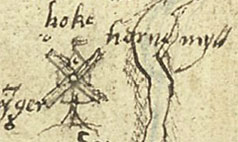
Horne Myll as depicted by a map from 1574
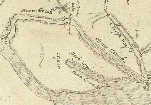
A map from 1574 shows a windmill just to the west of Hook (Hoke), when the piece of water defining Elmley island was known as ‘Straw Creak’. The mill was called Horne Myll (a post mill), and was probably situated close to where Windmill Quay is marked on some OS maps. A mill is also shown on a 1719 map, but disappears from maps by 1798.

The wind mill is marked near the top of Straw Creake which defines Elmley Island. Straw Creak on modern maps is now labelled as the Dray & Windmill Creek.
Crog Dick

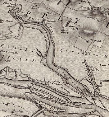
Map showing Crog Dick – it was once possible to take a small boat to within 1 mile of Minster via this creek!
Windmill Creek was once also known as Crog Dick (some texts refer to Croggdeepe, Crockdeepe, or Crog Deep). John William Norie writes in ‘Sailing Directions for the navigation of the North Sea’ published in 1823: “Boats or small vessels of five feet water may sail up Crog Dick to within a mile of Minster; with spring tides it joins Crog Dick in Clay Reach.”
Other uses:
Windmill Creek was a recognised way to bring goods to within one mile of Minster Abbey. The creek was probably also used by the vikings.
The 1953 floods:
Unfortunately, following the 1953 floods a decision was taken to dam off the lower end of the creek, and infill the top part of it, ending its long history as a waterway.
